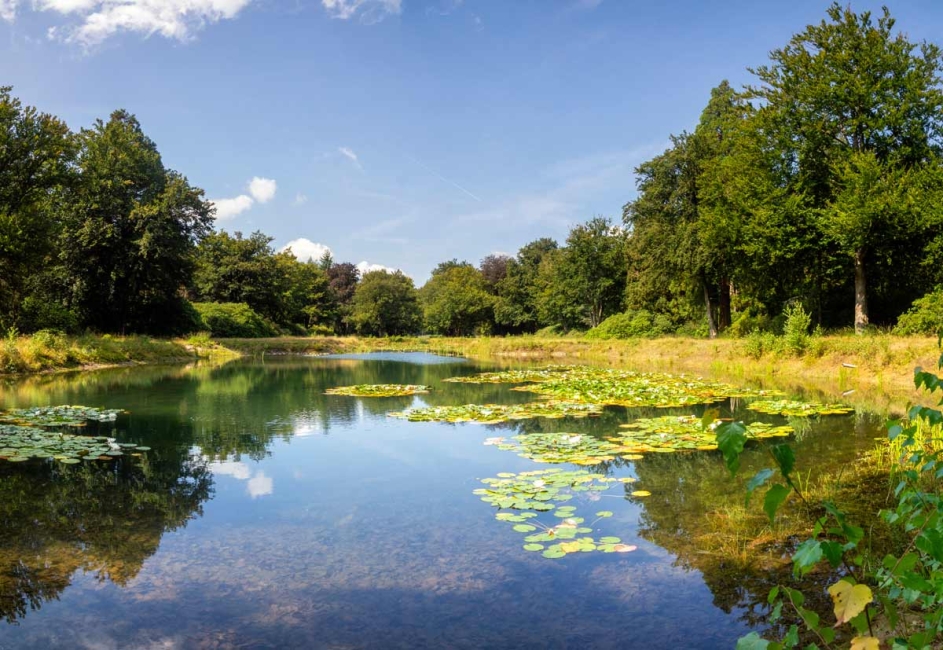
Riparian corridors, the vegetated strips that border rivers, streams, and lakes, serve as protective edges for both land and water. They filter pollutants, stabilize banks, slow floodwaters, recharge groundwater, and create habitat highways for fish and wildlife. When these corridors are degraded by agriculture, urbanization, or channelization, restoring their ecological integrity yields outsized returns for water quality, biodiversity, and community resilience.
Effective projects start with a clear understanding of current conditions and constraints.
| Task | Purpose |
|---|---|
| Geomorphic and hydrologic surveys | Document channel dimensions, flow regimes, erosion hotspots, and floodplain connectivity. |
| Biological inventories | Record vegetation, fish, macroinvertebrates, and invasive species to set restoration targets. |
| Land-use and stakeholder mapping | Identify property boundaries, infrastructure, and community priorities. |
Key takeaway: Data-driven baselines prevent “one-size-fits-all” solutions and make later monitoring meaningful.
Traditional riprap armor is costly and wildlife-unfriendly. Bioengineering combines structural support with living plants:
Live stakes and dormant cuttings (willow, dogwood) sprout fast, knitting soils together.
Coir fiber rolls and brush mattresses protect toe-of-slope zones while plants root through them.
Rootwads, log revetments, and engineered log jams slow velocities, trap sediment, and create fish cover.
Use hard armoring only where infrastructure is immediately threatened, and blend it with vegetative treatments to soften edges.
A diverse, layered plant community is the corridor’s living filter.
Set buffer width targets. A minimum of 35–50 ft on each side captures most sediment and nutrients, while 100 ft or more maximizes habitat benefits.
Select local ecotypes. Native sedges, rushes, grasses, shrubs, and flood-tolerant trees handle periodic inundation and out-compete invasives.
Plant in functional zones.
Toe zone: Sedges, rushes.
Bank zone: Willows, dogwoods.
Floodplain: Cottonwoods, sycamores, silver maples.
Employ multiple planting methods. Combine container stock for canopy species, bareroot plugs for ground cover, and direct seeding for grasses and forbs.
Mulch with weed-free straw or hydromulch, and water during the first two growing seasons if rainfall is irregular.
Many urban and agricultural channels have been oversized, straightened, or leveed.
Two-stage or inset floodplains add a low bench that overtops every one- to two-year storm, reducing shear stress and giving sediment a place to settle.
Levee set-backs and notches restore lateral connectivity, allowing high flows to spill safely across re-vegetated terraces.
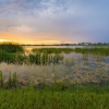
Backwater wetlands excavated at meander bends offer flood storage and breeding grounds for amphibians and birds.
Where flood risk to nearby structures is a concern, model design flows with HEC-RAS and coordinate with local flood-plain managers.
Healthy channels need structural complexity.
| Technique | Benefit |
|---|---|
| Large woody debris placement | Creates pools, refuge from predators, and grade control. |
| Riffle–pool or riffle–run sequencing | Oxygenates water and diversifies velocity zones for aquatic life. |
| Beaver dam analogues (BDAs) | Mimic natural beaver dams with posts and brush, reconnect floodplains, and raise water tables in degraded headwaters. |
Install habitat structures during low-flow periods to minimize turbidity spikes.
Integrated pest management combines manual removal, targeted herbicide spot-treatments, and biological controls such as stem-boring weevils for purple loosestrife.
Seasonal grazing exclusions with temporary fencing protect young plantings from livestock until root systems mature.
Recreation and access planning. Boardwalks, designated trails, and signage concentrate foot traffic, reducing trampling and rogue trails.
Riparian work pairs well with upland best management practices:
Green infrastructure (rain gardens, bioswales, permeable pavements) intercept stormwater before it reaches the corridor.
Nutrient management plans on adjacent farmland curb excess fertilizer runoff.
Urban street sweeping reduces heavy metals and hydrocarbons entering waterways.
Set measurable objectives, bank-erosion pin movement, percent native vegetative cover, macroinvertebrate diversity scores, and track them annually for at least five years. Adaptive management means adjusting planting densities, re-stabilizing eroded sections, or stepping up invasive control based on monitoring results.
Restoration rarely happens in isolation. Consider:
State clean-water or habitat grants (e.g., Section 319, Farm Bill programs).
Mitigation banking where developers fund projects that compensate for unavoidable impacts elsewhere.
Volunteer workdays with watershed groups and schools to plant and monitor, keeping costs down and building stewardship.
| Year | Milestone |
|---|---|
| 0 | Site assessment, design, and permitting |
| 1 | Earthwork (grading, floodplain reconnection), bank stabilization |
| 1–2 | Planting and initial invasive treatment |
| 2–5 | Monitoring, adaptive management, supplemental planting |
| 5+ | Long-term stewardship by local landowners or conservation district |
Restoring riparian corridors is equal parts science, engineering, and community engagement. By stabilizing banks with living materials, re-vegetating with native plants, reconnecting floodplains, and layering habitat structures, practitioners can revive the natural services these edges once delivered. When done well, the results ripple outward; cleaner water, richer biodiversity, reduced flood risk, and a corridor that future generations can enjoy.

 Stormwater culverts come in a wide range of materials, and each type carries a unique combination of strength, lifespan, cost, and installation consid…
 A well managed stormwater program depends on accurate and complete information about every outfall in a community. Outfalls are the final discharge po…
 When crews encounter contaminated sediments during routine work, or when a concerned homeowner reports a suspicious odor or unusual discharge, the sit…
 Opening and entering drainage structures requires a practiced, methodical approach that protects workers from unseen dangers and ensures that every st…
 Constructed wetlands are engineered systems that mimic the natural processes of a real wetland in order to treat stormwater, wastewater, or other poll…
 A complete and accurate stormwater map is one of the most important responsibilities for any community that operates as a Municipal Separate Storm Sew…